


National Geographic Linville Gorge / Mount Mitchell Topographic Map
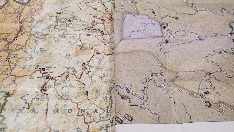
The Trails Illustrated Linville Gorge / Mount Mitchell topographic map provides an unparalleled tool for exploring these remarkable features within Pisgah National Forest.
- Expertly researched and created in partnership with local land management agencies
- Includes Linville Gorge Wilderness, Mount Mitchell State Park, Craggy Gardens, Grandfather Mountain Biosphere Reserve, Lake James State Park and Brown Mountain OHV Area
- Easy-to-read, yet highly detailed map shows comprehensive trail and road networks, along with designated trails for hiking, horseback riding, biking and more
- Clearly marked navigational aids with UTM coordinate grids, scale bar and full legend, essential for safely navigating the backcountry with GPS or compass
- Features key points of interest such as scenic views, campgrounds, trailheads, boat launches and picnic sites
- Color-coded boundaries for public lands including national parks, national forests, national monuments, ranger districts, wilderness areas, state parks and wildlife refuges
- 1:65,000 scale
- Printed in the USA on durable, lightweight, waterproof and tear-resistant material designed to withstand all weather conditions
- Folded dimensions: 4.25 x 9.25 in.; unfolded dimensions: 25.5 x 37.75 in.
- National Geographic Maps; copyright 2006
Made in USA.
View the National Geographic Trails Illustrated Product LineView all National Geographic Southeast Maps| Best Use | Hiking |
|---|---|
| State / Province | North Carolina |
| Map Number | 779 |
Write a Review
Adding a review will require a valid email for verification
Customer Images
Inaccurate trail illustrations
This map is in serious need of revision to the trail system. Missing trails, trails are shown that no longer exist, etc. Best bet for accuracy is the download the free constantly revised map providee by Linville Gorge Maps.
Better than nothing
The level of detail can be sometimes misleading and has caused me to mistakenly get on the wrong trail where two separate trails cross. It is certainly better than nothing but I would be wary of the absolute accuracy of the map as some trails appear to be of limited accuracy or entirely missing. The materials used to make this map do appear to be high quality and tear resistant and waterproof.
Drawback but good in a pinch
My wife and I went hiking in Wilson Creek recently and I wanted a map for the trip. I had doubts about this map from the get go and some turned out to be founded but what saved us in the end was the trail marking legend and the elevation indices. The map isn't detailed enough to clearly indicate creek crossings but the elevation markings definitely help when trying to determine if you're on the correct split. There is also a legend indicating the trail use (hiking/horse/atv) and whether the trails are marked and the associated marker color. The map is also reinforced so you can bend it all over the place to show the desired area and store as you like while out and about. If possible, get a better zoomed in map for your desired area. I also noticed Grandfather mountain at the top of the map doesn't show any of the trails I've hiked and know to be there. Yes this is a Linville Gorge map but there's a good 6 quare inches of the map over that region showing no trail.
Trail to Walk in the Future
Best maps ever. Love these. Very detailed and easy to read