


National Geographic Columbia River Gorge Topographic Map
Expertly researched in partnership with local land management agencies, the Trails Illustrated Columbia River Gorge topographic map offers an unparalleled tool for exploring this breathtaking region.
- Includes the White Salmon, Klickitat, Sandy and lower Deschutes rivers, Yacolt Burn State Forest and Maryhill, Columbia Hills and Rooster Rock state parks
- Also includes Mark O. Hatfield Wilderness and portions of Mount Hood and Gifford-Pinchot national forests
- Easy-to-read, yet highly detailed map shows comprehensive trail and road networks, along with designated trails for hiking, horseback riding, biking and more
- Clearly marked navigational aids with UTM coordinate grids, scale bar and full legend, essential for safely navigating the backcountry with GPS or compass
- Features key points of interest such as scenic views, campgrounds, trailheads, boat launches and picnic sites
- Color-coded boundaries for public lands including national parks, national forests, national monuments, ranger districts, wilderness areas, state parks and wildlife refuges
- 1:75,000 scale
- Printed in the USA on durable, lightweight, waterproof and tear-resistant material designed to withstand all weather conditions
- Folded dimensions: 4.25 x 9.25 in.; unfolded dimensions: 37.75 x 25.5 in.
- National Geographic Maps; copyright 2009
Made in USA.
View the National Geographic Trails Illustrated Product LineView all National Geographic Washington and Oregon Maps| Best Use | Hiking |
|---|---|
| State / Province | Oregon Washington |
| Map Number | 821 |
Write a Review
Adding a review will require a valid email for verification
Customer Images
Unsuitable for backcountry navigation.
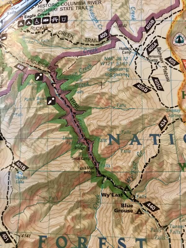
At best, Nat Geo's Columbia River Gorge map is an at-home reference tool. If you have an Internet connection (like right now because you're reading this) there are better and more accurate resources online--for free--but when you lose Internet or battery power, this is not the map you want for finding a trail camp or a connecting trail. The scale for this map is 1:75,000, or 1 inch = 1.2 miles, so there are no trail point mileage markers on this map (the adjacent Nat Geo Mt. Hood map is 1:35,000 or 1 inch = 0.6 miles, so it's not fair to make feature comparisons--if you have that map, please ignore any assumptions because it's likely a different cartography team made that Mt. Hood map). If you're determined to use this map in the field, bring along a compass with a powerful magnifying lens and your brightest headlamp. Scrunching 80+ miles of Columbia River details onto a two-sided map makes it exceptionally difficult to read, especially in the evenings at a camp site or in your tent. The publisher attempts to print too much at this scale. In places dark tint shading obliterates elevation contour lines in narrow valleys (see pic of Eagle Creek Trail). Unscaled symbols for multiple amenities, like those around Cascade Locks and Rooster Rock State Park, fill up map space to the point that you might need to consult another source to determine which side of the Columbia River you need to be on to access picnic spaces, boat launches and drinking water (!). This map was printed in 2009 and the listed declination is for 2009, so as of 2021 it's already two degrees off and relatively challenging for pinpointing your location with compass triangulation. (This is still better than Nat. Geo's Grand Tetons map, which currently shows 2008 declination data despite recent updates and printings.) If you require accurate hiking maps for this region, REI sells several Green Trails Maps that are more readable and feature recently updated declination variation data. This Nat Geo Columbia River Gorge map needs to stay at home.
Very Little Useful Info
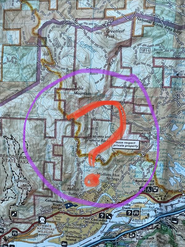
As the other person stated, this map is borderline useless. There are no mileage markings on any trails. Biggest thing… the ENTIRE Table Mountain trail system just doesn’t exist on this map. What?
Go-To Map for the Columbia Gorge
If you are ever looking for a map for the Columbia Gorge, this is it. Detailed, water resistant, tear resistant, just all around the best there is.