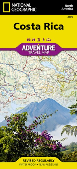


National Geographic Costa Rica Adventure Map
This product is not available.
Plan your trip and explore Costa Rica with this National Geographic map, featuring topography, detailed maps and useful guide information.
Shop similar products- Includes detailed road network coverage to get you there with confidence
- Shows protected areas clearly to help you find national parks, wildlife refuges, biological reserves, wetlands, forest reserves and more
- Printed on waterproof, tear-resistant paper for durability
- Shaded relief brings map to life, giving you the power to dream, plan and discover
- Includes insets of San Jose, Isla del Coco and Isla del Cano
- Shows all of Costa Rica at the largest possible scale of 1:350,000
- Folded map measures 9.25 x 4.25 in.; opens to 38 x 25.5 in.
- National Geographic; copyright 2002 (updated 2004)
Made in USA.
View all National Geographic Mexico, Central and South America Maps| Best Use | Travel |
|---|
Write a Review
Adding a review will require a valid email for verification
Location:Washington, D.C., United States
8 years ago
Great map for trip planning, and driving the roads
Yes , I recommend this product
Another beautifully presented, practical tool for advance planning and for navigating on the country's main roads. The country's many protected areas and parklands are clearly marked and so is the topography, which is really helpful. Has a good inset of central San Jose city. Bilingual English/Spanish text. Also has limited adjacent areas of Nicaragua and Panama. A product of the Adventure Maps series.
3 years ago
4 years ago