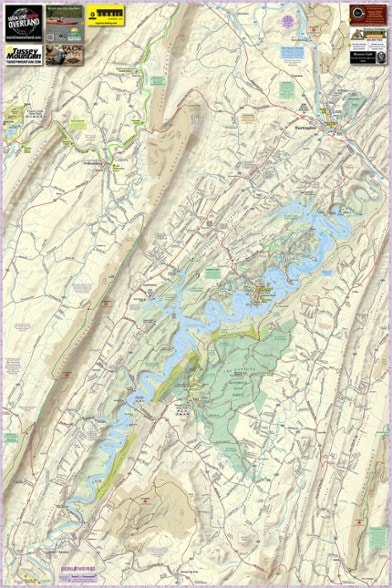


Purple Lizard Maps Raystown Lake Pennsylvania
$17.00
Bring along the rip-resistant, waterproof, topographic Purple Lizard Maps Raystown map to help you plan all your adventures on and around Raystown Lake in Pennsylvania.
- One side of the map covers all of Raystown Lake; scale is 1:45,135 (1 in. = 0.7 mi.)
- The other side has a detailed map of the Allegrippis Trail System and Trough Creek State Park; scale is 1:22,588 (1 in. = 0.4 mi.)
- Includes both latitude and longitude and UTM coordinate systems
- Maps feature contour lines, elevation data, shaded relief, lake depths and lake navigation markers
- Key planning details include backroads and trails, trail use designations, road surfaces (paved/gravel/4WD), parking access, campsites, public lands, historic sites and more
- Shows the 30-mile length of Raystown Lake from Huntingdon to Saxton, which is owned and managed by the U.S. Army Corps of Engineers
- Includes a section of Rothrock State Forest and Trough Creek State Park on the eastern side of Raystown Lake, Warriors Path and Canoe Creek State Parks
- Also includes parts of State Game Lands 67, 73, 99, 118, 322
- 323 mi. Mid State Trail (MST) shown from Lower Rail Trail south of Water Street to Williamsburg, continuing south on Tussey Mountain ridgeline on western side of Raystown Lake
- Map ends just after the MST crosses Route 165; on the eastern side of Raystown Lake, Terrace Mountain Trail follows the lake and has a shelter north of Trough Creek State Park
- Major biking trails are all about the Allegrippis Mountain Bike Trail System—a favorite destination for cyclists around the country
- This 33-mile network of mountain bike flow trails is considered one of the best riding experiences in the country; a mountain bike skills park is located by the Visitor Center
- Juniata College in Huntingdon has a network of walking paths and hiking trails around an environmental art installation by Maya Lin
- Seven Points Recreation Area offers multiple camping areas, a marina, rental boats, swimming beach, walking paths and picnic areas
- Ridenour and Hawn's Overlooks are easy to access and offer fantastic lake views; Trough Creek State Park in Rothrock State Forest has a historic balanced rock and an ice mine
- Covers the towns of Alexandria, Broad Top City, Huntingdon, Saxton, Saltillo and Williamsburg
- Highlights and designates public trails and paths including hiking, biking and rail trails managed by federal, state and local authorities
- Covers campgrounds, picnic areas, climbing areas, car camping sites and scenic overlooks; lizard icons signify cool places, sweet views, local legends and points of interest
Made in USA.
View all Purple Lizard Maps New England and Mid-Atlantic Maps| Best Use | Multisport |
|---|---|
| State / Province | Pennsylvania |
| Folded Dimensions | 8 x 4 inches |
| Unfolded Dimensions | 36 x 24 inches |
| Map Scale | 1:45,135; 1:22,588 |
| Double Sided | Yes |
| Waterproof | Yes |
| Publisher | Purple Lizard Maps |
| Copyright Year | 2021 |
Write a Review
Adding a review will require a valid email for verification
3 years ago