National Geographic Yosemite National Park Day Hikes Topographic Map Guide
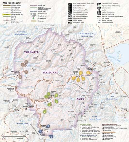
Featuring 18 diverse hikes for all hiking enthusiasts, the National Geographic Yosemite National Park Day Hikes topographic map guide unlocks the must-see sites in America's third national park.
- Includes hikes for every skill level, from an easy 2.8 miles along Hetch Hetchy Valley Overlook to the strenuous 14.7-mile Laurel Lake Trail with 3,900 ft. of elevation gain
- Each hike has a detailed map, a trail profile visualizing the changes in elevation and a short summary of the interesting features you'll encounter along the way
- Built for all levels of hiking enthusiasts, National Geographic Topographic Map Guides are more convenient and easier to use than folded maps
- Printed on "Backcountry Tough" waterproof, tear-resistant paper with stainless-steel staples
- Your purchase helps support National Geographic Society nonprofit's mission of research, education, conservation and exploration
Made in USA.
First protected in 1864 and designated as the 3rd national park in 1890, Yosemite is home to countless natural icons, including Yosemite Falls, the world's 5th tallest waterfall; El Capitan, one of the largest exposed monoliths of granite in the world; and Yosemite Valley and the Mariposa Grove of Giant Sequoias, which were the first scenic natural areas set aside by a national government for public benefit and appreciation.
With so many spectacular historical, scientific and scenic resources and recreational opportunities—which include backpacking, hiking, world-class climbing, fishing, camping and numerous winter pursuits—Yosemite has something for everyone.
| Best Use | Hiking |
|---|---|
| State / Province | California |
| Folded Dimensions | 9.25 x 4.25 x 0.3 inches |
| Map Scale | 1:50,000 |
| Double Sided | Yes |
| Waterproof | Yes |
| Publisher | National Geographic |
| Copyright Year | 2020 |
| Map Number | 1704 |
Write a Review
Adding a review will require a valid email for verification
Great maps for day hiking Yosemite
There are lots of free materials on Yosemite trails but I still really enjoyed this booklet of maps with suggested day hikes. The hikes are really great. The info provided for each hike is accurate and super helpful for figuring where to park and what to bring with you and how hard or easy the hike will be. So while these maps are not strictly speaking necessary for day hiking Yosemite, they were really helpful and allowed me to plan hikes on the fly, including going off trail when in the wilderness.
Nifty to have
I have the larger Yosemite Maps as well, but this is nice to have as well since it is a detailed look at specific hikes and areas.
Great product
These maps are some of the best. Durable, accurate, and easy to use and read.

