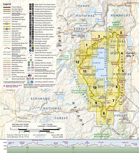
National Geographic Tahoe Rim Trail Topographic Map Guide
The Tahoe Rim Trail traverses some of the most spectacular scenery in the Sierra Nevada and Carson Ranges. Use the Trails Illustrated Tahoe Rim Trail topographic map guide to find your way.
- As it circumnavigates the beautiful Lake Tahoe Basin, the 175-mile Tahoe Rim Trail (TRT) climbs high peaks, offers tremendous views and dips in and out of flowery meadows
- This map guide is arranged for clockwise travel around the Tahoe Rim Trail starting at Tahoe City
- Each map page has a detailed trail profile that shows the elevation changes you will encounter
- The TRT is highlighted and centered on each page so you can easily track your progress
- Guide also includes detailed information about the 8 standard sections of the TRT; each section is from 15 to 30 miles and covers about 2 pages of the map guide
- More convenient and easier to use than folded maps, but just as compact and lightweight, the 40-page map guide booklet is printed on waterproof, tear-resistant paper
- A full UTM grid is printed on the map to aid with GPS navigation
Made in USA.
View the National Geographic Trails Illustrated Product LineView all National Geographic California Maps| Best Use | Backpacking |
|---|---|
| State / Province | California Nevada |
| Folded Dimensions | 9.25 x 4.25 inches |
| Unfolded Dimensions | Unavailable |
| Map Scale | 1:63,360 |
| Double Sided | Yes |
| Waterproof | Yes |
| Publisher | National Geographic |
| Copyright Year | 2018 |
| Map Number | 1013 |
Write a Review
Adding a review will require a valid email for verification
Heavy duty book style map
As always, National Geographic makes excellent maps. Like their other long trail maps it's book style where each page has shorter sections rather than the larger maps that unfold. Each of these has the normal topo map plus a chart of the elevation - incredibly useful when planning the day's mileage. I do find the book style annoying and, while heavy duty is good, I wish that there was an option that's perhaps less heavy duty but doesn't weigh as much. Ultralighters might balk at its 2.6 oz/73 gram weight. To put that in perspective, that's nearly three BRS stoves. You can always take pictures of the pages and use your phone, but that relies on batteries and might be redundant if you buy a GPS app.
Great Map!
Great to have paper maps still and dedicated to a specific trip!

