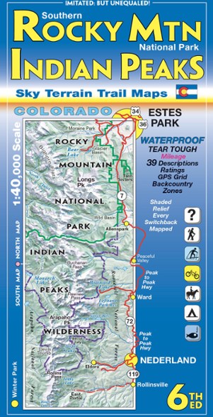

Sky Terrain Trail Maps Southern Rocky Mountain National Park and Indian Peaks Wilderness Trails - 6th Edition
This product is not available.
On trail or on the road, find your way with the waterproof Sky Terrain Southern Rocky Mountain National Park and Indian Peaks Wilderness Trail Map that folds to pocket-size for easy on-trail use.
Shop similar products- Waterproof, tear-resistant map provides durability in all conditions, and is built to withstand years of use in hand and on the trail
- Color-shaded topographic relief shows the stunning terrain in vivid detail
- Full UTM grid makes navigation easy with GPS and compass
- Information includes descriptions to 39 trails, with mileage between trail junctions and color-coded symbols to rate difficulty
- Recreation-focused trails ideal for hiking, mountain biking, skiing, 4WD, motorcycle, camping, fishing and more
- Easy-to-read symbols indicate all campgrounds and trailheads in the area
Made in USA.
View all Sky Terrain Trail Maps Colorado Maps| Best Use | Hiking |
|---|---|
| Folded Dimensions | 8 x 4 inches |
| Unfolded Dimensions | 36 x 24 inches |
| Map Scale | 1:40,000 |
| Double Sided | Yes |
| Waterproof | Yes |
| Publisher | Sky Terrain Trail Maps |
| Copyright Year | 2000 |
| State / Province | Colorado |
Write a Review
Adding a review will require a valid email for verification
Location:Boulder CO
Age:18–24
2 years ago
Best Map of the RMNP and Indian Peaks Area
Yes , I recommend this product
Best Map of the RMNP / Indian Peaks (and some of James Peak) that I've used. Tons of details and extras to this map. Highly recommended by REI staff as well when I was in store
Age:18–24