

Garmin inReach Explorer+
This product is not available. Good news: we have a newer version.
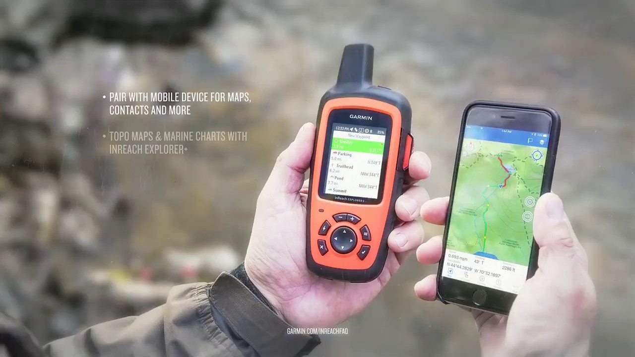
Roam far and wide without worrying your loved ones. The Garmin inReach Explorer+ is a GPS tracker, navigation tool, 2-way satellite messenger and SOS device all in one.
Shop newer version- Explorer+ has all the same functionality as the inReach SE+, but also has pre-loaded topo maps, 2 extra GB of memory, a digital compass, barometic altimeter and accelerometer
- Iridium satellite network ensures 100% pole-to-pole coverage with no gaps or fringe areas
- Send and receive text messages while beyond cellular range to any cell phone number, email address or to another inReach® (satellite subscription is required)
- Built-in, high-sensitivity GPS provides basic navigation, location and tracking data within 5 meters; follow routes, drop waypoints and find your way back
- Trigger an interactive SOS to GEOS, the 24/7/365 search and rescue monitoring center, to communicate the nature of your emergency
- Use the web-based MapShare portal to track and share your location online with family and friends so they can ping your device and exchange messages
- You can also use a cloud-powered portal to plan your trips with routes and waypoints, sync and manage your device, store all your location tracking data and much more
- Pair with mobile devices using the free Earthmate app for easier 2-way messaging and access to topographic maps and U.S. NOAA charts, color aerial imagery and more
- Internal, rechargeable lithium battery give up to 100 hours of battery life in tracking mode, up to 30 days in power-save mode
- Rugged, impact resistant and water-rated to IPx7—easily withstands rain, snow and splashes
- Includes USB cable and carabiner clip
Imported.
A subscription plan is required to send and receive satellite messages on this device. Visit vendor website to shop satellite subscription plans and additional services.
| Best Use | Backpacking Navigating Emergency Preparedness |
|---|---|
| Preloaded Map | Topo |
| Basemap | Yes |
| Wireless Communication | Yes |
| OS Compatibility | Windows / Mac |
| Display Size | 1.4 x 1.9 inches |
| Screen Pixels | 200 x 265 |
| Visual Map Display | Yes |
| Color Screen | Yes |
| Number of Waypoints | 500 |
| Compass | Yes |
| Altimeter | Pressure-based |
| Battery Type | Lithium Ion |
| Batteries | Rechargeable internal lithium ion |
| Average Battery Life | 100 hrs. (10 min. interval tracking) |
| Dimensions | 6.5 x 2.7 x 1.5 inches |
| Water-Resistance Rating | IPX7 |
| Weight | 7.5 ounces |
Write a Review
Adding a review will require a valid email for verification
Customer Images


Most Helpful Favorable Review
Most Helpful Critical Review
First GPS unit
My wife and I were backpacking from the Lake Eleanor dam in Yosemite to the campsites in Lake Eleanor. The trail sign said it was a mile and a half. The trail was so overgrown with shrubs and downed trees that we couldn't even see the trail. Our Garmin Inreach Explorer came in real handy. It seamed like the longest mile and a half we have ever backpacked, but we make it because of our GPS. The bluetooth linking capabilities to my iPhone were very handy as well. Not to mention that i was able to share all of our trip data on social media. This will come in handy on our JMT hike coming up in August. I am very happy with this product so far.
Oh how I wish I had not purchased this!
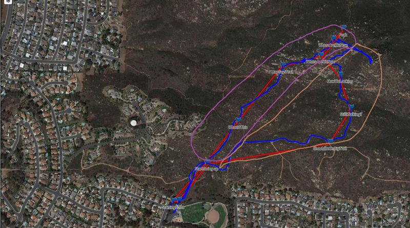
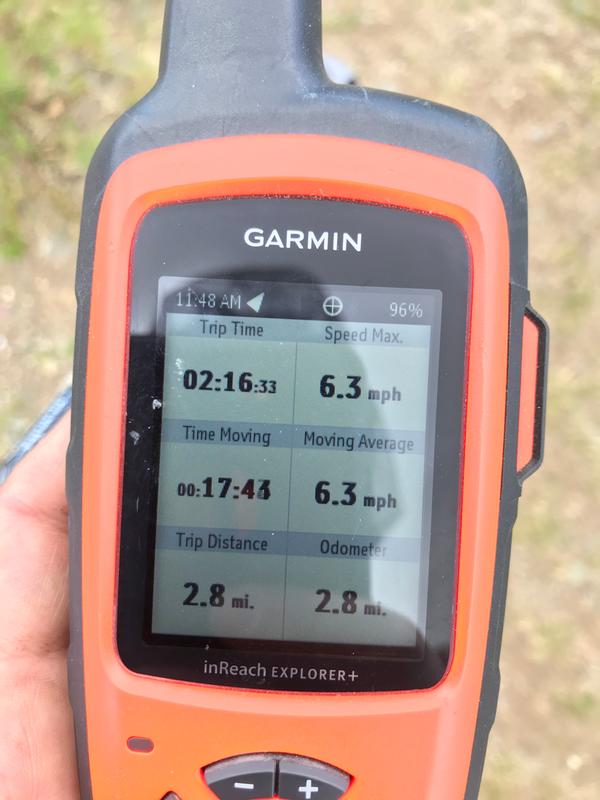
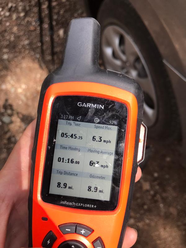
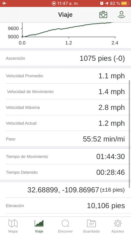
BUYER BEWARE!!! If you think there is something wrong with your Inreach, return it within the 30 days no matter what!!! From the moment I started to use my Inreach it has not worked as advertised. I had to fight to get a ticket opened (17022308) because the customer service reps just want you to change the same settings and call back... even when you are following THEIR engineer’s instructions and trying to provide requested test results. I’ve now paid for the device, plus three months of service charges, and can’t use any data from my hikes. This thing reports that I travel at superhuman speeds (23+ mph), no average speeds, and most recently that I hiked from 9,000 to 10,600 feet at 6.3 miles an hour, carrying 32 lbs, in only 18 minutes. FTK’s here I come! For the money spent, it’s pretty discouraging that my beat up iPhone 7, running a free version of Gaia is WAY more accurate than my Inreach. I feel Garmin strung me along until I couldn’t return it to the store. Now I am roped into to a service I can’t even use. Even worse, they haven’t even had the courtesy to credit my account for the money they’ve take without rendering promised services.
Keeping a connection.. not so great
Most of the time it wouldn’t be connected even when leaving out of my pack with the antenna pointing up sometimes messages wouldn’t come in until a day or so later to long for when your needing to check in to keep someone from coming to look for you. Not sure if this is normal or not but I could not hardly get it to connect in a wide open area with it propped up and Antenna pointing straight up to an open sky it was really frustrating i our $50 a month for unlimited messages and tracking but it honestly is not very reliable I bought it and don’t want to lose a lot of money on it so I have kept it so far but would really like to find something out there that’s more efficient and reliable.
WAS SAVED BY THIS DEVICE!
I did a solo backpacking trip in the Grand Canyon of the Tuolumne in Yosemite later in the year - so it was pretty quiet. Day 1 I clocked about 23 miles and was deep into the canyon, the morning of Day 2 I dislocated my knee.... Day 3 I was lucky as two amazing gentlemen had this guy and I was able to text some friends to come meet up with me and help with the slow process of getting out. I now own one of these guys too, and if I am not using it I am sending it out with a friend. My other GPS barely works in Yosemite and this one didn't have a problem in a canyon. The service plans are great and it's nice to know you can get help if needed.
inReach and the dead car battery
Yosemite’s Tioga Road. A trailhead parking lot halfway to Tuolumne Meadows. 7 pm and getting dark. No cell service; no wifi; miles to the nearest pay phone. Dead car battery. Not good. Waived down a driver who said he’d stop in Tuolumne Meadows and call a tow truck. Nearly three hours later, no help has come. The stars are out and the temperature is dropping. Out came the inReach Explorer+. We texted our son--who was at home 200 miles away--via the satellite connection. He called road service, kept in touch with us. The tow truck came and we avoided a cold night in the empty parking lot. That's how the inReach proved its worth.
Peace of Mind
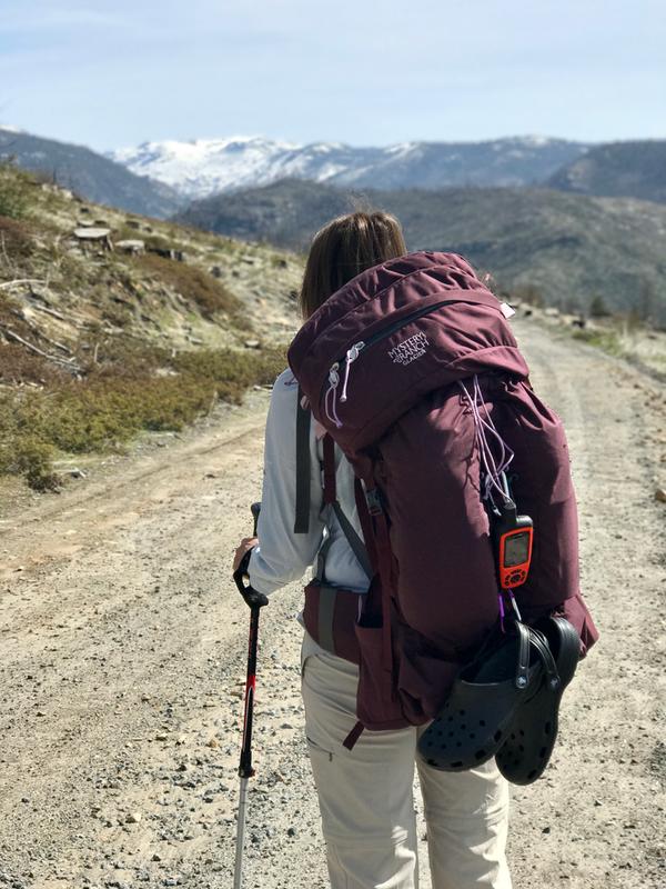
As an older solo hiker/bushwhacker, this device has given peace of mind to my family that allows me to go into some very remote areas by myself. Having the ability to communicate no matter where I'm at has made the Garmin inReach worth every penny, plus knowing if an emergency arises, I can summon help with the push of a button. I like the ability to see where I am and where I have been, recording distance and speed traveled, checking the weather report and using the preset messages that you can customize. When I am out or in camp it is alway turned on and attached to me or my pack. It has become the one piece of gear that I will not go without.
Safety is inReach
Wow, there are certainly a lot of people writing negative reviews on this product. A lot of people seem to have negative reviews of the configuration but for me it was nothing short of smooth and perfectly operational within a few short steps. Is it highly configurable? Yes. This is not a device that you leave as is. You customize and configure the maps, waypoints, routes, comm settings as you see fit. This includes the public portal that exposes your journey to your family and friends. People forget that just ten years ago we didn't have iPhones and now we are communicating our movements and texts using space satellites in near real time. Nothing short of AMAZING.
Unfortunate big disappointment
The interface and entire menu setup is like something from the early 1980s. Unfortunately, I'm not joking. Really, really disappointing. We took the device to hike to "The Wave", Coyote Buttes in Arizona. We finally just gave up and used the US Interiors map and a compass. After returning home, we just returned the device to REI. Certainly not worth the price of the device. In addition to that of course INREACH continued to try and charge our credit card bill for months "after" we cancelled our subscription with them. I'd say this experience was an overall nightmare. In the year 2021, over 50 years year after the moon landings, you'd think they have something just a little bit better that this?
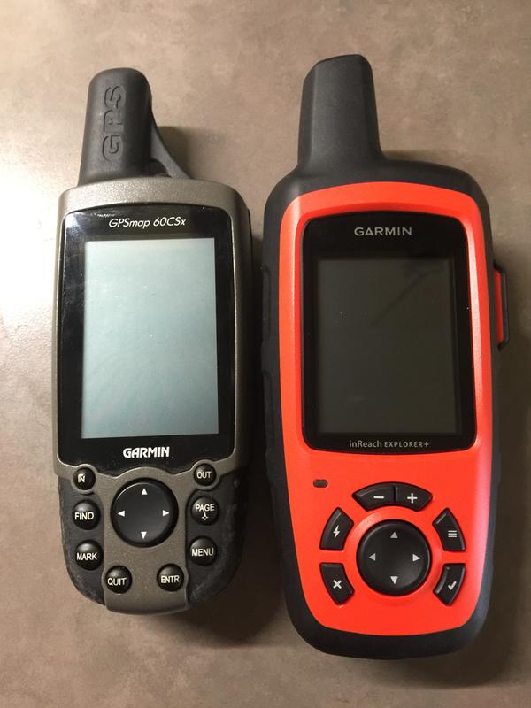
Satellite communication Yes - GPS No
Bought this new Garmin as soon as it was released. In fact, I was on a waiting list so that as soon as it hit store shelves I would be one of the first to receive it. I was really anticipating getting rid of my old Garmin 60csx and using the gps feature of the in-reach. Not so fast, it really lacks in Gps features, mapping during tracking and on map accuracy. I use UTM coordinates and have found that both units are agreeable in location. So if I needed to trigger an SOS I am pretty confident rescuers could find me. Personal texting and email has worked fine with about 20 texts and emails that I have sent and received through satellite. Absolutely glad that I purchased this unit and would purchase again. Just don't expect a lot out of the gos mapping and tracking features.
Poor Garmin support information/videos.
The Garmin Inreach Explorer +, is a good GPS unit. My only complaint is the total lack of instruction by Garmin on how to use each of the features that the unit offers. The manual is more of a quick start of some of the features. The support videos offered are very long but do not really cover how to use the unit but instead, One spends several minutes listening to a product support manager that likes himself a lot. I would love a 5 to 10 minute video that explains what each feature is and a demonstration of how to use it. I am hopeful that when the COVID sanctions are lifted, that REI has a class so this unit with all of it’s features is taught to me.