

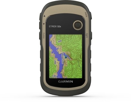
Garmin eTrex 32x
Explore confidently with the Garmin eTrex 32x handheld GPS featuring a compass, altimeter, preloaded maps and a 2.2 in. sunlight-readable color display.


This purchase pays for membership!
$28
10% Reward
on this and every eligible full-price item*
+
$30
Bonus Card
valid for 60 days after joining*
=
$58
Value
Keep shopping

- Comes with TopoActive mapping featuring routable roads and trails to explore when hiking or cycling; add even more maps via the microSD™ card slot and 8 GB of internal memory
- Support for GPS and GLONASS satellite systems, along with a 3-axis compass and barometric altimeter, allows for tracking in more challenging environments than GPS alone
- 2.2 in. sunlight-readable color display with 240 x 320 display pixels for improved readability
- Preloaded with TopoActive maps with routable roads and trails for cycling and hiking
- 8 GB of internal memory for map downloads plus a microSD™ card slot
- Battery life: up to 25 hrs. in GPS mode with 2 AA batteries
Imported.
View all Garmin GPS Devices| Best Use | Multisport Navigating |
|---|---|
| Preloaded Map | Topo |
| Basemap | Yes |
| Wireless Communication | Yes |
| OS Compatibility | Windows / Mac |
| Display Size | 2.2 inches |
| Screen Pixels | 240 x 320 pixels |
| Visual Map Display | Yes |
| Color Screen | Yes |
| Number of Routes | 200 |
| Number of Waypoints | 2,000 |
| Internal Memory | 8 gigabytes |
| Expandable Memory | Yes |
| Compass | Yes |
| Altimeter | Pressure-based |
| Quad Helix Antenna | Yes |
| Compact Antenna | Yes |
| Position Accuracy | 3 meters |
| Battery Type | Alkaline |
| Batteries | 2 AA |
| Average Battery Life | Up to 25 hours |
| Dimensions | 4 x 2.1 x 1.3 inches |
| Water-Resistance Rating | IPX7 |
| Weight | 5 ounces |
Review this Product
Adding a review will require a valid email for verification
Living in the past: USB 1.1 and 32GB micro SD
Unbelievable they would charge this much and not include enough storage space for the maps. That requires 10GB for the map update for North America, with only 8 on board and the micro SD (requires FAT32!) with an allowed range of 4-32 GB. What year is this, 2006? They don’t have the decency to put the extra $8 into the onboard storage? Really? Top that off with AA batteries and the USB speed is 1.1, mini USB interface, no Linux support, buggy software on the Mac/PC side and we have a real loser here. Would NOT recommend.
Rubber cracks on thumb stick
This is the second etrex that has had the thumb stick crack. The first died from the leak in Norway. The second I am keeping dry for now. Garmin solution is for me to buy a new device, when replacing the face plate would fix the problem. Good device if you buy a new one every year or two.
Electronic compass is good; maps are disappointing
This model is exactly the same as the 30x with the following differences 1) internal memory has been expanded from 3.7 to 8 GB, 2) Maps with significant more detail than a standard base map come loaded. However, the maps are not the well polished maps you purchase from Garmin but appear to have an Open Street Map origin (i.e., I was surprised to see my local trail maps incorporated into these maps). Maps are much more likely to "miss-route" and send you a 100 miles out of the way than Garmin's City Navigator map. The processor is slower than the higher end Garmin Handhelds and has a slow USB connection (2.0?). What's good? The 2.2" display has the highest pixel count per inch of any handheld and has a clear display. The three-axis electronic compass appears to update once per second, but is very accurate and is more reliable than the current top-end 66 series. Overall, the 32x is a nice looking, palm size GPS that has a full, rich set of features, just less that top end maps and a slow processor. I have a GPSMap 66s and an Oregon 600 to compare it to and I end up using this one the most.
Counterintuitive
The user interface for this device is not very intuitive. Way points are important, for example, but there is one place for setting them, another for managing them, and another for navigating to them. It should be easy to set a distant waypoint and then see it on a map. It's not. Similar criticisms can be said about tracks and routes as well. It should also be easy to set a way point from coordinates found from other sources. eTrex requires you enter them only in Degrees, Minutes and fractions of a minute. Some sources supply coordinates in degrees and fractions of a degree, for example while others give coordinates in degrees, minutes and seconds. That means that I have to do the calculations to translate one system to the other. Why shouldn't eTrex allow you to choose the format? On the other hand, it is pretty nice to be able to see exactly where you are on the map, and to zoom in and out. That's relatively easy. It comes loaded with some pretty decent maps. However, the screen is small, which is good, but scrolling up & down or left & right is cumbersome. Just as important the maps don't have the names of many, if not most geographic features. Names would really help orient what the eTrex says to the physical map I navigating with. It would also be nice if the map would display altitude and coordinates, or at least coordinate tick marks so that you don't have to move from screen to screen to get view critical information. I'm still learning to use it, so there may be ways of using it that are easier than I've found. But I spent too much time on a recent trip futzing around trying to get it to do what I wanted it to do, only to give up. It was frustrating and disappointing.
Easy to use, accurate, palm size
I have used the eTrex 20, 22 and 32. Love them for fitting in my palm and requiring almost no work to hold when I need to use it all day. The 32 has more memory and comes with a better topo map. The screen is clear and bright, and I never kill rechargeable batteries within a day. This is an inexpensive device, so don't expect super detailed maps. I prefer the 'joystick' to a touchscreen (which seldom works with sweat or rain), but the first sign of failure on my 20 was when pressing the joystick led to shut down rather than selecting something. This is the weak point - though mine have never cracked. To protect the screen, buy tempered glass protectors. They are dirt cheap, and can be replaced many times. As to the long review saying nothing made sense, please extract head. E trex are easy to use. By selecting "Setup" from the main menu, and then "Position Format" you can select whatever Lat/Long or UTM format you like, and then enter points using that format. (By changing your selection, the eTrex will automatically convert your points to the new format.) You can enter a point (your current location) from ANY page by pressing and holding the joystick. You can then change coordinates to a desired location. The only thing I dislike is that eTrex tries to push you into using the "Go" mode, which I find maddeningly unhelpful. I can't figure out how to remove from my map the annoying pin that is placed when you do hit "Go" inadvertently (and far too easily). (OK, someone tell me how stupid I am and explain this) Overall, a great simple GPS. My 20 lasted almost 7 years, and I tortured it in extreme heat and overstuffed it with waypoints from a long term project.
Nice affordable GPS
Nice affordable GPS and compact size, does the job without spending too much money, sharp screen good resolution, easy to navigate.
Awesome Little GPS
I love my new eTrex 32x. So far it works as advertised. I will update this review after I field test the device.