I started my watch at 5:26am as I left my hotel in Cascade Locks, the Columbia River Gorge town where I began my southbound thru-hike of the Pacific Crest Trail (PCT) through Oregon. It was the last Monday of June 2025, and I was eager to beat the heat: Temperatures were forecast to top 90°F.
Oregon has three designated “alternates” to the main Pacific Crest Trail: the Rim Trail around Crater Lake, a small detour in Mount Hood to see a 120-foot waterfall and the Eagle Creek Trail—which I was now starting—featuring picturesque waterfalls like the iconic Tunnel Falls, where hikers can walk behind a curtain of water.
I had last hiked the Eagle Creek Trail in 2016. Back then, it was lush and wet. But on September 2, 2017, a teenager threw a firecracker into a dry ravine along the Eagle Creek Trail during a burn ban, igniting a fire that burned some 48,000 acres of the trail and surrounding areas in the weeks to come.
Now, the surviving Douglas firs flanking the trail greeted me again, bearing charred scars at the base of their trunks. The nearby hills glowed bald in the morning light. Six miles in, I reached my first view of Tunnel Falls. Before this area burned, I gasped in awe at first sight: a bold line of water framed by trees dripping with moss. Now, bare conifers lined the cascade, which still thundered into a basin below. The forest’s fibrous flesh was gone, but lifeblood still ran through it.
No one says it outright, but many thru-hikers consider burn zones less “worth” hiking than what they imagine to be pristine forest.
Before my 2025 trip, someone in a PCT Facebook group asked about large trail sections in Washington ‘with fire damage that aren’t pretty to hike through’ On trail, I met hikers who skipped days of hiking through scorched terrain in northern California, hoping for greener pastures in Oregon. Those hiking northbound told me about long stretches of burn zones I had coming up, complaining about the lack of shade and miles of blowdowns. On FarOut, an app that helps plan water sources, campsites and resupplies, users routinely comment on campsites in newly burned areas, warning others of widow makers— burned, weakened trees that could fall on your tent overnight. Hiking through burn zones requires attention and care. You can’t just move on cruise control.
But the Pacific Crest Trail, like so many other trails, is constantly changing as wildfires become more frequent and intense. Even though fires have long been natural and necessary for maintaining healthy forests, decades of fire suppression, diminishing snowpack, prolonged heat and drought, and climate-change-driven lightning strikes have made fire an ever-present force.
To immerse yourself in a changing trail is to be a part of nature’s story. If the trail changes, hikers who choose to experience it ought to change alongside it—to shift our expectations, to prepare ourselves for the hazards these changes might present. To experience a burn zone, in all its stages, is a privilege—a chance to witness the wilderness as it transforms.
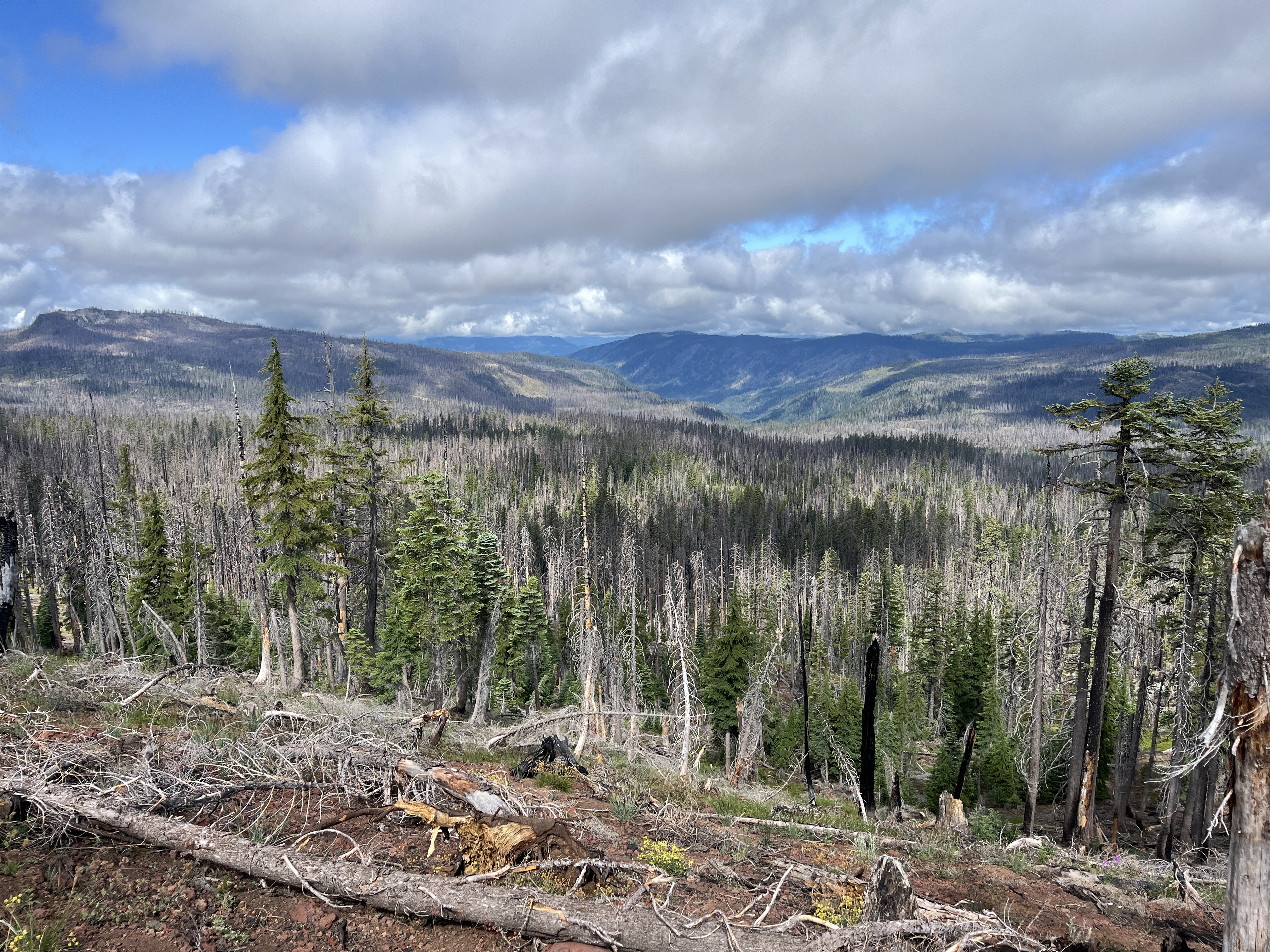
That first hot day, I continued deeper into the heart of the Eagle Creek burn. There was no shade, but instead of focusing on what was missing, I noticed what had returned in the fire’s aftermath: Bushes of hemlock, thimbleberries, salmonberries and small patches of wild strawberries lined the trail. Fireweed and tiger lilies bloomed bright and defiant. Young conifers, not more than 3 feet tall, dappled the landscape. As I climbed, I saw more of the 2017 burn at scale. I wondered why the fire stopped where it did and why some tree stands survived while others were burned. Why, in any disaster, are some spared while others are decimated?
Most of the Eagle Creek fire burned in a classic mosaic, which means the severity varied across the burn area. Mosaic fires aren’t anomalies: They’re part of what once created the forests hikers now idealize as “untouched.” Indigenous communities used fire to cultivate mosaic landscapes. They cleared land for crops, encouraging the growth of specific plant species, and supporting wildlife. The result was akin to a patchwork quilt: Fire was intentionally used to, say, cordon patches of forest with grasslands, prairies or wetlands. Burns helped create ecological diversity and reduce otherwise catastrophic wildfires’ severity. Colonization removed many Indigenous communities’ ownership of their land; the US. Forest Service’s establishment encouraged forest managers to criminalize Indigenous prescribed-burning traditions. Without this kind of fire, forests have continued to grow unchecked. Ironically, the continuous forests hikers romanticize, which have emerged as a result of fire suppression, are what fire ecologists see as a ticking time bomb. “Continuous forests everywhere is a recipe for very large fires that can charge large areas all at once and reduce seed source for the next forest,” explains University of Washington forest ecologist Susan Prichard. Fires today may infuse some quality of the mosaics that were created at much larger scales prior to settler colonialism, she says. They may not fit today’s vision of wild beauty—that is, miles and miles of verdant overstory—but they sure were functional.
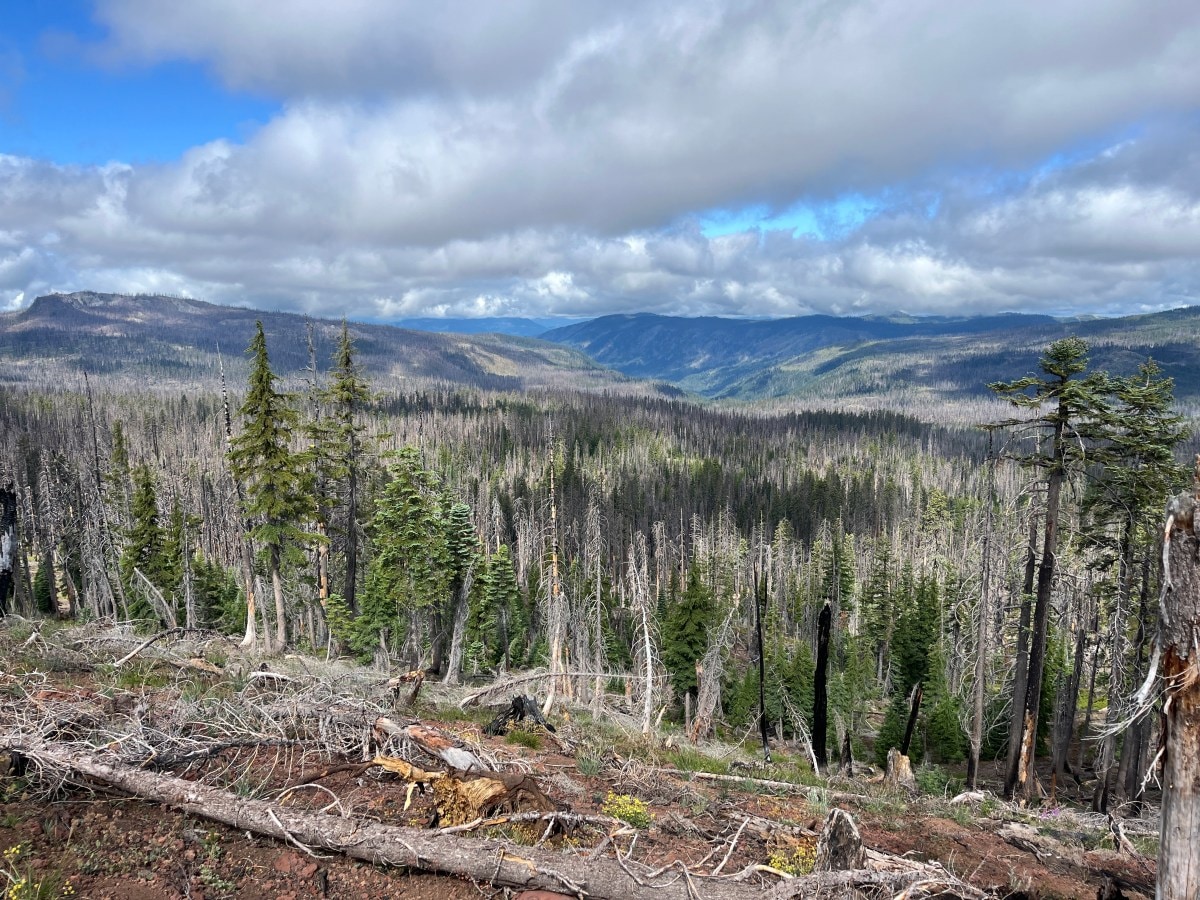
By the time I got south of Mount Hood, I encountered burn zones nearly every day. I’m the type of hiker who is constantly checking the Gaia GPS app—I want to know where I am, what peaks I’m looking at and more about the history beneath my feet. On the app, I use the US Geological Survey’s Historical Wildfire Layer, which shows the boundaries of past years’ fires.
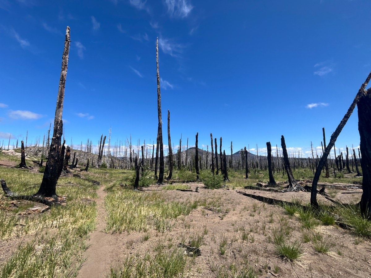
On July 4, I walked through land burned in the 2014 Logging Unit fire. The next day, I entered the burn scar from the 2020 Lionshead fire. That burn was so massive—larger than New York City—that I continued hiking through it the next day. The landscape there struck me: Even five years after the burn, the landscape was dotted with obsidian toothpicks, the soil ash gray. Only small shrubs were beginning to take hold.
Ten days later, I crossed into the 2022 Cedar Creek fire zone. Grassy clumps and clusters of violet one-seeded pussypaws were emerging—the beginnings of life in an exposed, sun-scorched landscape.
In these unshaded, high-severity burns, the heat felt unrelenting, even with adequate water and sun protection. But, what if that’s the point? Wildfires are brutal, and so are the forces that have made them more common: settler colonialism, corporate climate science denial, extractive legislative policies. Why should the backcountry be exempt from the systems that otherwise shape the world we live in?
In these seemingly barren areas, I also couldn’t help but wonder about the burn’s story, the land’s story. Who were the Indigenous stewards who tended this place prior to colonization, and how? How did the fires start? How hot did they burn? How did it ultimately end? If the scorched trees could speak, what would they say? Lost in my musings wandering through the Cedar Creek burn, one tree spoke to me. It stood tall, its crown obliterated in the fire. What remained looked like a middle finger, cursing everything that took away its home.
Fire ecologists and researchers tend to measure post-wildfire recovery in terms of tree regeneration. But Prichard and her colleagues believe measuring tree regeneration isn’t the only way to determine if a forest is recovering. Some forests can rebound in a few years; others take centuries. “If it takes five to ten years to [start recovering], that’s a blink in the longer timescale of how forests operate,” fire ecologist Brian Harvey told me.
Instead, there’s a lot to pay attention to before total regeneration happens. Wildflowers, for example, bloom in these scorched landscapes. Fireweed, lilies, shooting stars and penstemon’s small lilac-colored buds can brighten a landscape. To Prichard, the explosion of color is like a second fire. Many of these areas become much more diverse, as well. Harvey studies recovery in Washington’s Norse Peak fire zone, which burned approximately 10 miles of the PCT in 2017. Eight years later, the new growth is more diverse than before.
Fire is destructive, he says, “but it’s opening space for nature’s creative process to unfold.”
On July 21, south of Crater Lake, I entered the 2017 Blanket Creek burn when a hiker donning neon green pants approached. Obi-Wan (his trail name) exchanged pleasantries as he waited for his brother, Chug Jug, to catch up. We noted how comfortable the temperatures felt, particularly walking through a burn zone. Some of the conifers were growing back, but not enough to build a shady overstory.
When I told them the burn happened in 2017, they looked at each other in an I-told-you-so kind of way. The brothers had been guessing the ages of regrowth in burn zones. I mentioned the Gaia app’s wildfire layer; they seemed eager to check it out.
Our conversation was brief, but it stayed with me. It was the only moment on trail when I experienced curiosity—not complaint nor dismissal—when talking about burn zones. It made me wish more hikers had the same type of wonder.
Considerations of Recreating in Burn Zones
Hiking in a burn zone is different from hiking on a wooded trail unaltered by fire, and it comes with unique hazards. Here are some practical tips for staying safe.
Check the Weather
If you plan on camping or recreating in burn zones, check the weather before you go. Trees that have been burned, even at the base, are very unstable and can topple over in high winds. If you’re camping, set up your tent away from trees scarred by fire. Burnt trees are often called “widow makers” because they can unexpectedly fall or lose branches, causing serious injury or death. “They [can] be coming down for probably a decade or more following some of these fires,” says Harvey.
Use Sun Protection
Burn zones offer little shade. Be prepared with sunscreen, a wide-brimmed hat and sun-protective clothing.
Stay Hydrated
Sun exposure may increase the risk of dehydration. If you choose to filter water from lakes in burn scars, be mindful that the sediment load increases after a fire, which could put more stress on your water filter.
Protect Your Feet
Use gaiters to prevent debris from entering your shoes because ash can cause friction and blisters if it gets in them. If you’re prone to blisters, consider taking off your socks during a break to air out your feet.
Stay on Trail
After a fire, forests are more susceptible to nonnative or invasive species taking a foothold, says Harvey, because there’s more space available. Brush off boots and clothing both before and after hikes, and stay on trail to minimize spreading foreign species.
Watch Your Footing and Stay Aware
Any time there’s a dead tree, there’s the potential of rotting wood and roots. Morels (which fruit after a forest fire) may draw foragers off trail, but know that burned wood may collapse underneath your feet. In winter, skiers should be cautious: Shallow snowpack may hide sharp snags.