
Salty air, seagulls calling, and waves for days
Our distinct coasts provide unique running opportunities: sunny, hot, foggy, or chilly—your choice. With miles of coastline, the trail options are endless, but these are our favorites.
Lands End
Location: San Francisco, CA
Length: 2.9 miles (round-trip)
Difficulty Rating: Easy/Intermediate

Photo: Scazon, Flickr
With less than 200 feet of vert, Lands End is an easily runnable trail with often-foggy views of the Bay Area’s iconic coast. The trail is formed on an old rail line, so the majority of it is flat going, but you’ll hit a steep section of stairs along the way. You can explore the historic Sutro Bath remains, but the real reason to run Lands End: unbeatable vistas of the Golden Gate Bridge and the Pacific Ocean.
Cape Lookout Trail
Location: Cape Lookout State Park, OR
Length: 2.4 miles (one-way)
Difficulty Rating: Intermediate
Cape Cod Lookout is a quiet, out-and-back trail on a lush Oregon peninsula that juts out into the Pacific. A relatively easy and well-groomed route, the only difficulty you’re likely to encounter here is mud. Sloppy going or not, Cape Lookout is more than worth it. The trail’s dense forest opens up into an immense and forthright view of the Pacific.
Clubhouse Beach Out and Back
Location: Everglades National Park, FL
Length: 12.8 miles (round-trip)
Difficulty Rating: Easy
Pound the marl trail, made of crushed coral, on this 13-mile haul through Everglades National Park. Cotton pickers and fisherman once used the road, but today it makes for one of the best runs in the park. Explore forest and sawgrass prairie until you finally hit the coastline at the halfway point. There, you’ll see unobstructed views of the Florida Bay.
Lost Coast Trail
Location: King Range National Conservation Area, CA
Length: 27.3 miles (one-way)
Difficulty Rating: Intermediate
Untamed by roads, the Lost Coast Trail is long, rugged, and pretty much off the grid. Unique among America’s coastline, Lost Coast is unspoiled by homes, roads, and other human interferences. Switchbacks, hard inclines, and slippery rock are all fair game. The trail takes you from pristine, hidden beaches to high vistas with unimaginable views of the coast. At times, the trail is clouded by marine fog, and during high tide, sections are covered in water, so plan your run accordingly.
Ocean Path
Location: Acadia National Park, ME
Length: 2.1 miles (one-way)
Difficulty Rating: Easy/Intermediate
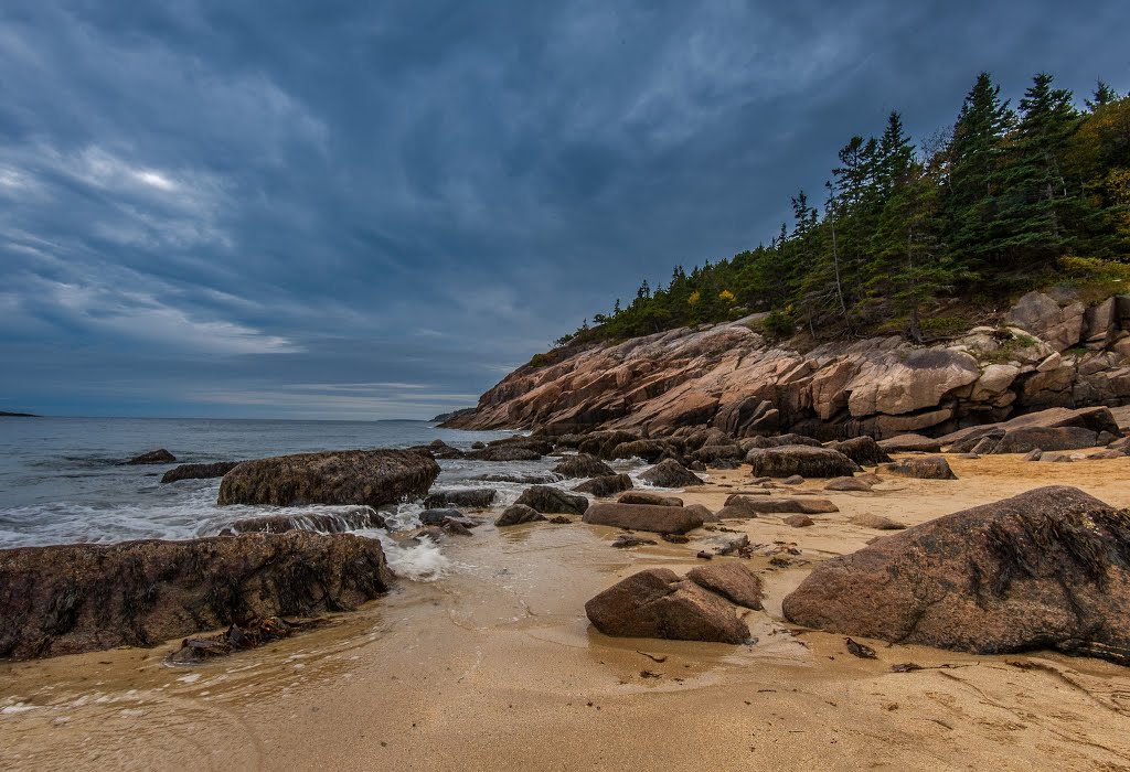
Photo courtesy of E Koh
Ocean Path is queen bee at Acadia National Park. Pink granite rock formations and towering pines line this trail along the classic Maine coastline. Although the trail itself is not challenging, crashing waves, tide pools, and Thunder Hole (a sea cave) add depth to this beautiful route. This is a real East Coast gem, so make sure you stop to take in the scenery.
Mountains-to-Sea Trail, Segment 15B: North Carolina
Location: Coastal North Carolina
Length: 93.3 miles (one-way)
Difficulty Rating: Easy/Intermediate
Want to get to know North Carolina? Run the Mountains-to-Sea Trail. Ultrarunners, rejoice. Though a whopping 93 miles long, this is just a small chunk of the entire 1150-mile route. It takes you along North Carolina’s diverse coastal bend, Onslow Bright, and winds through sea turtle and waterbird nesting areas. Cross small towns, state parks, and game land along the way, and the striking views of the coast are just the icing on the cake.
Ozette Triangle
Location: Olympic National Park, WA
Length: 9.6 miles (round-trip)
Difficulty Rating: Intermediate
The Ozette Triangle is made up of over nine miles of picture-worthy trail, taking you through forests and bogs to the coast. Shaped like a triangle, this loop is all about the water, edging up to a lakeshore on one side and the ocean on the opposite. The trail also passes through Cape Alava, the westernmost spot in the contiguous states, and during low tide, you can walk out to Tskawahya Island.